

Okay, so we’ve all met the old bushie down the track with a great camper trailer. You know, the one you’d follow through a raging storm who can spot a water source by observing the wings on a bird. Wouldn’t it be great if you could develop some of those same skills? Well, with a little orienteering you can.
Orienteering is the skill that helps you visualise what’s behind the hill and the first step to achieving this is knowing how to read a map.
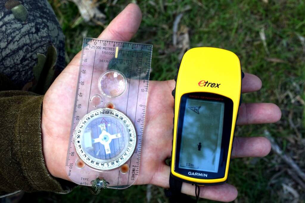
While GPS is great for getting you from A to B, when you’re learning to read a map there’s no better place to start than on the classic fold-out AO bonnet-size sheet.
There are a few types of maps available to help guide you to your favourite camping destination, but if you really want a feel for the terrain or head off road, a topographical map is hands down the best way to go. Drawn from land surveys, topographical maps are to scale and show important landmarks such as roads, rivers, boundaries, as well as vegetation, and the lay of the land, represented in the contour lines.
Looking over a topographical map can be confusing at first, but if you follow the rules found within its margins you’ll be navigating the tracks before long. See our run-down below.
One of the most significant characteristics of a map is the scale. This tells us the ratio of the distance between what’s on the map to what’s on the ground. For example, a scale of 1:50,000 tells us that every unit on that map covers 50,000 of those same units on the ground.
The bigger the second number (say, 1,800,000 on a 1:1,800,000 touring map) the greater distance covered on the map but this vast coverage comes at a cost — and that’s detail. Touring maps are great for travelling across the country via major routes but if want to do a bit of exploring or find a campsite, you’re better off using one that’s scaled between the 1:200,000-1:50,000, which should show you things such as campsites, minor roads and a few dirt tracks as well.
Those who like to hoof it, rock climb or enjoy hard-core offroading will find maps scaled to 1:25,000/1:35,000 extremely useful in those situations.
Below the scale bar, you’ll find the ‘contour interval’ note, to help you make sense of all those curves or ‘contours lines’ squiggled all over the map. Each contour line represents a height above sea level. And the contour interval number tells you the difference in height between one contour line to the next. This measurement doesn’t change, which is why contour lines are close together when you’re looking at a steep valley or hill and far apart on an open plain.
A map that covers a flat area may have contour lines with contour intervals of about 10m, while maps with mountain ranges may have contour intervals closer to 50m.
The north point diagram is what you use to set your compass to local bearings, by spelling out the difference between the three norths: that is, grid north, magnetic north and true north.
‘Grid north’ (GN) is a universal standard adhered to locally so all Australian topographical maps point to GN. ‘Magnetic north’ (MN) is the direction your compass needle points as a result of the earth’s magnetic field.
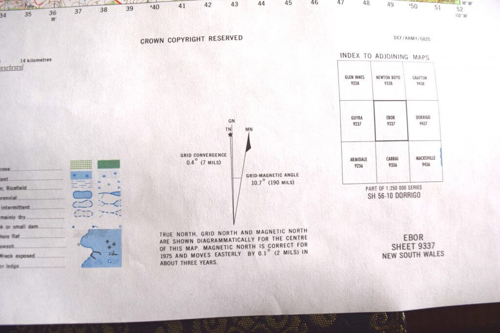
If you want to match your compass to what you see on the map, refer to the number representing the difference in degrees between the GN and MN and adjust. If you’re working with a manual compass, that’s usually simply a case of dialing the face. This figure varies throughout Australia so it’s an important one to watch.
True north is the direction towards the north pole. It changes from year to year but you don’t need to worry about that too much as it’s not essential for successful navigation.
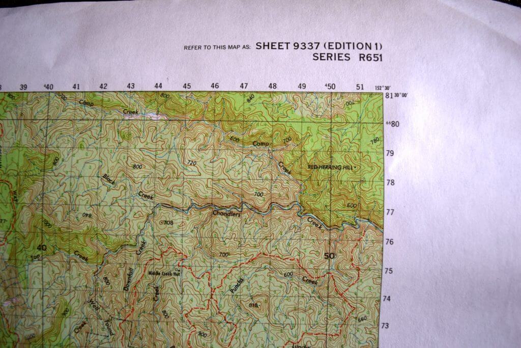
The grid reference box tells you how to put together a map grid reference using the ‘eastings’ and ‘northings’ on the map. Eastings correspond to vertical lines at the top of the map and the northings correspond to the horizontal lines and are indicated on the side. Eastings and northings have many numerals in them which makes them appear very complicated, but the truth is you only need the first few digits of each to plot a course.
To plot your location to within 100m, combine the first three of your landmark’s nearest easting with the first three digits of your landmark’s nearest northing, and voila!
Here is where you’ll find all the definitions for all the graphics on your map, including line details for the major and minor roads and icons for servos, campsites, dump points and so on. Many maps share similar icons but it’s always a good idea to take a squizz at the legend before emptying the tanks as there’s no official universal standard for map roadways graphics and icons.
At Mars Campers we work hard to develop the best value for money camper trailers with a view of helping you create memorable experiences with your loved ones.
Did you find this information useful? If you found even one tiny nugget in this material to be useful, please do forward it to three of your friends. I am sure they will thank you for it. You can send it to them via email, Twitter, Facebook or post it on your own website.